

Technology at Your Fingertips
Efficient and reliable tool to solve urban problems
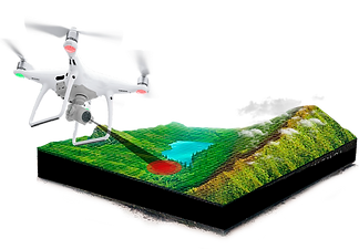
While it is true that the constant advancement of technology has given us different tools to facilitate various tasks,one of them is the use of drones that are being improved every time to provide us with a variety of services in different areas.
For the development and improvement of urbanizations we can use this tool that will help us to develop efficiently and provide possible solutions to various problems in a faster and safer way. We have made a fusion of the data that drones, satellites, etc. can provide us with. for the development of this web page that will allow us to track possible solutions to problems or find the main cause.
 |  |  |
|---|---|---|
 |  |  |
Technology Which You Can Control


TOPOGRAPHY


Sustainable Development


TRAFFIC


DataFromSky is an implemented software whose function is to record, analyze and extract data (whether it is human or vehicle traffic). In addition, it contains a tecnology called "fisheye" that allows night vision without distortion. The software allows you to identify what type of vehicle it is (motorcycle, car, truck, etc.), it also has sensors that can predict if an accident is going to happen. Another important function they have is that they detect the capacity of space in a square.
SECURITY


Providing a Number 1 Service
Pix4D software provides the best security where it is possible thanks to the evolution of technology, which has made the development of cameras and sensors smaller and lighter.
Future Plans
The drone can collect the data and send it in real time to the national emergency cabins (police, firefighters, hospitals), in order to maintain national control of each person.
Facilitates The Search
Using this drone as complex areas such as mountains or rivers to have a visualization of what is happening in the place. Thanks to the best latest model thermal camera.
Emergency plans
Helping in the search for people, given its ease by the 4K camera and thermal camera. In this way we can prevent people from directly exposing themselves to danger.
Be in Touch
We want to hear from you!
Tel: 123-456-7890 | Fax: 123-456-7890
500 Terry Francois Street San Francisco, CA 94158


Learn All About the Advantages that Our System Has to Offer
Safe and reliable for urban development
Accessible from All Locations
IA tool that will contribute to sustainable development and social growth in a safer and more reliable way for citizens. Facilitating the daily life of each of the people, and providing solutions to existing problems. In such a way that it would avoid possible risks in constructions in progress after a good analysis of surfaces.
An easy-to-use application but with complementary tools to support urban development problem solving.


